Log in
All resources
Create a design
Tools
7,171 Free Images of Atlas Map
maps from university of amsterdam special collections
atlas der neederlanden
copperplate print
special collections of the university of amsterdam
national library of poland
gemeente atlas van nederland - north brabant
piet schipperus
maps by hendrik hondius the younger
british library
atlas ou representation du monde universel t. 2 (1633)
maps from university of amsterdam special collections
atlas der neederlanden
maps by john cary
1799 maps
atlas maior, vol 3 (germany) - joan blaeu, 1667 - bl 114.h(star).3
copper engraving print
atlas maior, vol 3 (germany) - joan blaeu, 1667 - bl 114.h(star).3
copper engraving print
atlas maior, vol 3 (germany) - joan blaeu, 1667 - bl 114.h(star).3
copper engraving print
media from regionaal archief alkmaar
sint pancras
maps in the library of congress
1780s maps of cuba
gemeente atlas van nederland - drenthe
maps of de wolden
atlas ou representation du monde universel t. 1 (1633)
maps of england by gerardus mercator
atlas ou representation du monde universel t. 1 (1633)
maps by hendrik hondius the younger
atlas ou representation du monde universel t. 1 (1633)
maps by hendrik hondius the younger
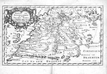
old administrative maps of the ottoman empire
1909 maps of asia
maps of galicia by mercator-hondius
1619 in galicia (spain)
beschreibung und contrafactur der vornembster stät der welt, liber primus civitates orbis terrarum
maps of koblenz by braun & hogenberg
siege of sluis 1604
old maps of sluis
maps by christian sgrothen
topographischer atlas der schweiz
weberei säge schindellegi
beschreibung und contrafactur der vornembster stät der welt, liber primus civitates orbis terrarum
maps of rothenburg ob der tauber by braun & hogenberg
gemeente atlas van nederland - north brabant
lithoijen
gemeente atlas van nederland - north brabant
liempde
gemeente atlas van nederland - north brabant
diessen
french-language maps
1742 maps
atlas ou representation du monde universel t. 2 (1633)
maps by hendrik hondius the younger
africa
maps
maps by christian sgrothen
wurm
maps from university of amsterdam special collections
atlas der neederlanden
atlas ou representation du monde universel t. 2 (1633)
1630s maps of lower saxony
maps of europe by mercator-hondius
ateliers bmb mercator
atlas maior, vol 3 (germany) - joan blaeu, 1667 - bl 114.h(star).3
copper engraving print
atlas maior, vol 3 (germany) - joan blaeu, 1667 - bl 114.h(star).3
nova & accurata ducatuum slesvici et holsatiae tabula
baumwollspinnerei im sood
fabrikkanal sihltal
atlas maior, vol 2 (sweden, russia, poland, eastern europe, and greece) - joan blaeu, 1667 - bl 114.h(star).2
copper engraving print
maps from university of amsterdam special collections
atlas der neederlanden
gemeente atlas van nederland - north brabant
geffen
maps by christian sgrothen
rheindahlen
map of ghent by jan blaeu
sint-lievenspoort (ghent)
daniel de la feuille
1708 maps
gemeente atlas van nederland - north brabant
maps of werkendam
gemeente atlas van nederland - north brabant
maps of deurne, netherlands
maps from university of amsterdam special collections
atlas der neederlanden
maps from university of amsterdam special collections
atlas der neederlanden
maps from university of amsterdam special collections
atlas der neederlanden
maps from university of amsterdam special collections
atlas der neederlanden
maps from university of amsterdam special collections
atlas der neederlanden
gemeente atlas van nederland - drenthe
maps of aa en hunze
maps by willem and johannes blaeu
17th-century maps of chile
maps of north america, nypl collection
novi belgii, atlas maior
maps from university of amsterdam special collections
atlas der neederlanden
maps from university of amsterdam special collections
atlas der neederlanden
maps from university of amsterdam special collections
atlas der neederlanden
maps from university of amsterdam special collections
atlas der neederlanden
coats of arms on maps
atlas novus (blaeu)
atlas minor gerardi mercatoris (1609)
maps of china by mercator-hondius
maps by willem and johannes blaeu
maps from university of amsterdam special collections
atlas der neederlanden
maps from university of amsterdam special collections
atlas der neederlanden
maps from university of amsterdam special collections
atlas der neederlanden
maps from university of amsterdam special collections
atlas der neederlanden
maps from university of amsterdam special collections
atlas der neederlanden
civitates orbis terrarvm, liber primvs (1577)
maps of tangier by braun & hogenberg
maps of aa en hunze
gieten
maps of amersfoort by braun & hogenberg
atlas de wit 1698
gemeente atlas van nederland - gelderland
maps of renkum
19th-century maps of vaucluse
1852 maps of france
gemeente atlas van nederland - groningen
maps of termunten
atlas ou representation du monde universel t. 2 (1633)
maps of the county of mansfeld
atlas ou representation du monde universel t. 2 (1633)
maps of vicenza
atlas ou representation du monde universel t. 2 (1633)
maps by hendrik hondius the younger
atlas ou representation du monde universel t. 2 (1633)
maps by hendrik hondius the younger
atlas ou representation du monde universel t. 2 (1633)
1633 maps of africa
atlas ou representation du monde universel t. 2 (1633)
1633 maps of asia
gemeente atlas van nederland - south holland
old maps of gouda
old maps of doetinchem
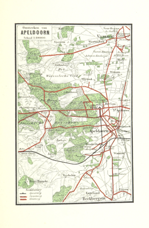
piet schipperus
maps of apeldoorn
piet schipperus
maps of utrechtse heuvelrug
piet schipperus
gemeente atlas van nederland - north brabant
meeuwen, netherlands
17th-century maps of moscow
16th-century maps of moscow
map of maastricht by willem and johannes blaeu (1649)
markt (maastricht)
maps by christian sgrothen
maps of rur
atlas maior, vol 9 (italy) - joan blaeu, 1667 - bl 114.h(star).9
1667 maps of italy
travel
maps
background
maps
maps of paris from paris musées
baroque
background
maps
gemeente atlas van nederland - north brabant
maps of woudrichem
gemeente atlas van nederland - north brabant
maps of vught
avignon in the 17th century
atlas van loon
old maps of guizhou
maps from gallica
gemeente atlas van nederland - limburg
maps of tegelen
maps by john cary
1801 maps
maps by willem and johannes blaeu
17th-century maps of the world
gemeente atlas van nederland - north brabant
maps of woudrichem
atlas maior, vol 3 (germany) - joan blaeu, 1667 - bl 114.h(star).3
celeberrimi fluvii albis nova delineatio by willem janszoon blaeu
old maps of gelderland
piet schipperus
old maps of alkmaar
piet schipperus
old maps of haarlem
piet schipperus
maps of breda, netherlands
piet schipperus
old maps of twente
piet schipperus
old maps of gelderland
piet schipperus
old maps of nijmegen
piet schipperus
3501 - 3600 of 7,171
Next page
/ 72

![Map of Holland and Surrounding Provinces - Nicolaus Visscher, Gilliam van der Gouwen, [after 1705]](https://cdn.creazilla.com/illustrations/10000302103/map-of-holland-and-surrounding-provinces-nicolaus-visscher-gilliam-van-der-gouwen-after-1705-sm.webp)


![Gerardi Mercatoris and I. Hondii Atlas or Representation of the Universal World, and of the Parts of It, Made in Tables and Descriptions Very Ample, and Exact: Divided into Two Volumes [...]. [t. 1].](https://cdn.creazilla.com/illustrations/10000720637/gerardi-mercatoris-and-i-hondii-atlas-or-representation-of-the-universal-world-and-of-the-parts-of-it-made-in-tables-and-descriptions-very-ample-and-exact-divided-into-two-volumes-t-1-sm.webp)
![Gerardi Mercatoris and I. Hondii Atlas or Representation of the Universal World, and of the Parts of It, Made in Tables and Descriptions Very Ample, and Exact: Divided into Two Volumes [...]. [t. 1].](https://cdn.creazilla.com/illustrations/10000604152/gerardi-mercatoris-and-i-hondii-atlas-or-representation-of-the-universal-world-and-of-the-parts-of-it-made-in-tables-and-descriptions-very-ample-and-exact-divided-into-two-volumes-t-1-sm.webp)
![Gerardi Mercatoris and I. Hondii Atlas or Representation of the Universal World, and of the Parts of It, Made in Tables and Descriptions Very Ample, and Exact: Divided into Two Volumes [...]. [t. 1].](https://cdn.creazilla.com/illustrations/10001462413/gerardi-mercatoris-and-i-hondii-atlas-or-representation-of-the-universal-world-and-of-the-parts-of-it-made-in-tables-and-descriptions-very-ample-and-exact-divided-into-two-volumes-t-1-md.jpg)


![Beschreibung und Contrafactur der Vornembster stät der Welt, liber primus [Civities of the World], 1574](https://cdn.creazilla.com/illustrations/10000943568/beschreibung-und-contrafactur-der-vornembster-stt-der-welt-liber-primus-civities-of-the-world-1574-sm.webp)


![Beschreibung und Contrafactur der Vornembster stät der Welt, liber primus [Civities of the World], 1574](https://cdn.creazilla.com/illustrations/10001206722/beschreibung-und-contrafactur-der-vornembster-st-t-der-welt-liber-primus-civities-of-the-world-1574-sm.jpg)


![Gerardi Mercatoris and I. Hondii Atlas or Representation of the Universal World, and of the Parts of It, Made in Tables and Very Ample Descriptions. [t. 2].](https://cdn.creazilla.com/illustrations/10001326081/gerardi-mercatoris-and-i-hondii-atlas-or-representation-of-the-universal-world-and-of-the-parts-of-it-made-in-tables-and-very-ample-descriptions-t-2-md.jpg)


![Gerardi Mercatoris and I. Hondii Atlas or Representation of the Universal World, and of the Parts of It, Made in Tables and Very Ample Descriptions. [t. 2].](https://cdn.creazilla.com/illustrations/10001514456/gerardi-mercatoris-and-i-hondii-atlas-or-representation-of-the-universal-world-and-of-the-parts-of-it-made-in-tables-and-very-ample-descriptions-t-2-md.jpg)


![Map of the Slaperdijk stretching from the Stichtse mountains to the height of Gelderland / ... Justus van Broeckhuysen ... measured and charted accordingly ... in September 1705; [engraved by Caspar Specht], Caspar Specht, 1705](https://cdn.creazilla.com/illustrations/10001105269/map-of-the-slaperdijk-stretching-from-the-stichtse-mountains-to-the-height-of-gelderland-justus-van-broeckhuysen-measured-and-charted-accordingly-in-september-1705-engraved-by-caspar-specht-caspar-specht-1705-md.jpg)
![Map of the Nieuwe Tonge in the lovely country of Grys Oort / Heyman van Dyck fecit; A. Steyaart invented; I. Shutters fecit cum aqua forti; I. Stemmer's sculpsit, Romeyn de Hooghe, [1701]](https://cdn.creazilla.com/illustrations/10001291381/map-of-the-nieuwe-tonge-in-the-lovely-country-of-grys-oort-heyman-van-dyck-fecit-a-steyaart-invented-i-shutters-fecit-cum-aqua-forti-i-stemmer-s-sculpsit-romeyn-de-hooghe-1701-md.jpg)
![Map of the Slaperdijk stretching from the Stichtse mountains to the height of Gelderland / ... Justus van Broeckhuysen ... measured and charted accordingly ... in September 1705; [engraved by Caspar Specht], Caspar Specht, 1705](https://cdn.creazilla.com/illustrations/10001202757/map-of-the-slaperdijk-stretching-from-the-stichtse-mountains-to-the-height-of-gelderland-justus-van-broeckhuysen-measured-and-charted-accordingly-in-september-1705-engraved-by-caspar-specht-caspar-specht-1705-md.jpg)
![Map of the Slaperdijk stretching from the Stichtse mountains to the height of Gelderland / ... Justus van Broeckhuysen ... measured and charted accordingly ... in September 1705; [engraved by Caspar Specht], Caspar Specht, 1705](https://cdn.creazilla.com/illustrations/10001411130/map-of-the-slaperdijk-stretching-from-the-stichtse-mountains-to-the-height-of-gelderland-justus-van-broeckhuysen-measured-and-charted-accordingly-in-september-1705-engraved-by-caspar-specht-caspar-specht-1705-md.jpg)
![General map of the entire lordship and jurisdiction of Grys Oort / Heyman van Dyck fact; I. Shutters fecit cum aqua forti; A. Steyaart invented; I. Stemmer's sculpsit, Romeyn de Hooghe, [1701]](https://cdn.creazilla.com/illustrations/10001487784/general-map-of-the-entire-lordship-and-jurisdiction-of-grys-oort-heyman-van-dyck-fact-i-shutters-fecit-cum-aqua-forti-a-steyaart-invented-i-stemmers-sculpsit-romeyn-de-hooghe-1701-sm.webp)


![Carte particuliére de l'Isle d'Amboine / J. V. Schley direct, Jakob van der Schley, [1763]](https://cdn.creazilla.com/illustrations/10000789471/carte-particuli-re-de-l-isle-d-amboine-j-v-schley-direct-jakob-van-der-schley-1763-md.jpg)
![Thieler Waard – Card with Hochwasserschutz 1729, Willem Albert Bachiene, [1759]](https://cdn.creazilla.com/illustrations/10000488312/thieler-waard-card-with-hochwasserschutz-1729-willem-albert-bachiene-1759-md.jpg)
![Thieler Waard – Card with Hochwasserschutz 1729, Willem Albert Bachiene, [1759]](https://cdn.creazilla.com/illustrations/10000639099/thieler-waard-card-with-hochwasserschutz-1729-willem-albert-bachiene-1759-md.jpg)


![Map of the polder of the old Oost dyck in West Voorn / A. Steyaart invenit; I. Stemmer's sculpsit; I. Shutters fecit cum aqua forti; H. van Dyck fecit, Romeyn de Hooghe, [1701]](https://cdn.creazilla.com/illustrations/10000341870/map-of-the-polder-of-the-old-oost-dyck-in-west-voorn-a-steyaart-invenit-i-stemmers-sculpsit-i-shutters-fecit-cum-aqua-forti-h-van-dyck-fecit-romeyn-de-hooghe-1701-md.jpg)
![Map of the Slaperdijk stretching from the Stichtse mountains to the height of Gelderland / ... Justus van Broeckhuysen ... measured and charted accordingly ... in September 1705; [engraved by Caspar Specht], Caspar Specht, 1705](https://cdn.creazilla.com/illustrations/10000611407/map-of-the-slaperdijk-stretching-from-the-stichtse-mountains-to-the-height-of-gelderland-justus-van-broeckhuysen-measured-and-charted-accordingly-in-september-1705-engraved-by-caspar-specht-caspar-specht-1705-md.jpg)
![Map of the polders of Out and Nieuw Herckingen / Heyman van Dyck fecit; I. Shutters fecit cum aqua forti; A. Steyaart invented; I. Stemmer's sculpsit, Romeyn de Hooghe, [1701]](https://cdn.creazilla.com/illustrations/10000842157/map-of-the-polders-of-out-and-nieuw-herckingen-heyman-van-dyck-fecit-i-shutters-fecit-cum-aqua-forti-a-steyaart-invented-i-stemmer-s-sculpsit-romeyn-de-hooghe-1701-md.jpg)
![Map of the Slaperdijk stretching from the Stichtse mountains to the height of Gelderland / ... Justus van Broeckhuysen ... measured and charted accordingly ... in September 1705; [engraved by Caspar Specht], Caspar Specht, 1705](https://cdn.creazilla.com/illustrations/10001438819/map-of-the-slaperdijk-stretching-from-the-stichtse-mountains-to-the-height-of-gelderland-justus-van-broeckhuysen-measured-and-charted-accordingly-in-september-1705-engraved-by-caspar-specht-caspar-specht-1705-md.jpg)
![Map of the Slaperdijk stretching from the Stichtse mountains to the height of Gelderland / ... Justus van Broeckhuysen ... measured and charted accordingly ... in September 1705; [engraved by Caspar Specht], Caspar Specht, 1705](https://cdn.creazilla.com/illustrations/10001059198/map-of-the-slaperdijk-stretching-from-the-stichtse-mountains-to-the-height-of-gelderland-justus-van-broeckhuysen-measured-and-charted-accordingly-in-september-1705-engraved-by-caspar-specht-caspar-specht-1705-md.jpg)


![Gerardi Mercatoris and I. Hondii Atlas or Representation of the Universal World, and of the Parts of It, Made in Tables and Very Ample Descriptions. [t. 2].](https://cdn.creazilla.com/illustrations/10001013822/gerardi-mercatoris-and-i-hondii-atlas-or-representation-of-the-universal-world-and-of-the-parts-of-it-made-in-tables-and-very-ample-descriptions-t-2-sm.webp)
![Gerardi Mercatoris and I. Hondii Atlas or Representation of the Universal World, and of the Parts of It, Made in Tables and Very Ample Descriptions. [t. 2].](https://cdn.creazilla.com/illustrations/10000739776/gerardi-mercatoris-and-i-hondii-atlas-or-representation-of-the-universal-world-and-of-the-parts-of-it-made-in-tables-and-very-ample-descriptions-t-2-md.jpg)
![Gerardi Mercatoris and I. Hondii Atlas or Representation of the Universal World, and of the Parts of It, Made in Tables and Very Ample Descriptions. [t. 2].](https://cdn.creazilla.com/illustrations/10001371723/gerardi-mercatoris-and-i-hondii-atlas-or-representation-of-the-universal-world-and-of-the-parts-of-it-made-in-tables-and-very-ample-descriptions-t-2-sm.webp)
![Gerardi Mercatoris and I. Hondii Atlas or Representation of the Universal World, and of the Parts of It, Made in Tables and Very Ample Descriptions. [t. 2].](https://cdn.creazilla.com/illustrations/10001497746/gerardi-mercatoris-and-i-hondii-atlas-or-representation-of-the-universal-world-and-of-the-parts-of-it-made-in-tables-and-very-ample-descriptions-t-2-sm.webp)
![Gerardi Mercatoris and I. Hondii Atlas or Representation of the Universal World, and of the Parts of It, Made in Tables and Very Ample Descriptions. [t. 2].](https://cdn.creazilla.com/illustrations/10001256230/gerardi-mercatoris-and-i-hondii-atlas-or-representation-of-the-universal-world-and-of-the-parts-of-it-made-in-tables-and-very-ample-descriptions-t-2-md.jpg)
![Gerardi Mercatoris and I. Hondii Atlas or Representation of the Universal World, and of the Parts of It, Made in Tables and Very Ample Descriptions. [t. 2].](https://cdn.creazilla.com/illustrations/10000298832/gerardi-mercatoris-and-i-hondii-atlas-or-representation-of-the-universal-world-and-of-the-parts-of-it-made-in-tables-and-very-ample-descriptions-t-2-sm.webp)


![Queicheu imperii sinarum provincia decimaquarta / [tirée du P. Martini]; Exc. I. Blaeu, 1655](https://cdn.creazilla.com/illustrations/10001381799/queicheu-imperii-sinarum-provincia-decimaquarta-tire-du-p-martini-exc-i-blaeu-1655-sm.webp)


